November 25, 2017

Cycling around Northland

 There are options for cycling around Northland. The first consideration is where to start the ride. If you are cycling up from Auckland I strongly advise against cycling up the main road to Whangerei as the carriageway is to narrow to provide a shoulder for bikes and the high volume of cars and heavy trucks. It is better to take an alternative route or to catch a bus from Auckland and to start your ride in Whangerei.
Route from Auckland North:

http://newzealandcycletouring.blogspot.co.nz/2015/03/cycle-touring-out-of-auckland-north.html

The first option to see Northland on a bike is to ride the Pou Herenga Tai Twin coast cycle trail which goes from the Bay of Islands to the Hokianga Harbour. Details of this ride can be found on the following link. It will give you a good taste of what Northland has to offer.

https://www.nzcycletrail.com/trails/twin-coast-trail/

If you wish to see the whole of Northland then the following route will allow you to do this.


I have just completed a 750 kilometre ride around Northland that started in Whangerei and went up the east coast and then to Cape Reinga and then went down the west coast to Dargaville. From there we cycled back to Whangerei. There are some big hills to ride up but there are some great beaches and places to stay on the route.


On the first day from Whangerei to Whangaruru we went on a back country route which avoided the main road.  It was shingle which can be difficult to ride on.


If you stay at camping grounds these usually have choices of camp sites and huts which are ideal for cycle touring. On the second day we headed to Kerikeri a distance of 76 kilometres and on the following day we rode to Matauri Bay. This is a great beach with a camping ground on the foreshore. There was big hill out of Matauri Bay as we headed to Cable Bay via Russell and Waitangi.


Matauri Bay
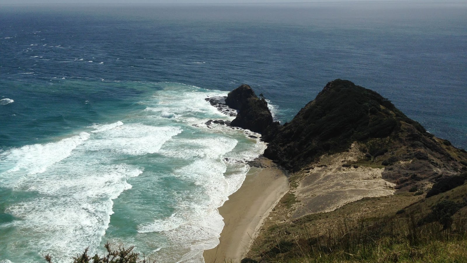
There is a spectacular coastline to ride along and there are some big hills. We then rode out to the Karikari Peninsula which is a very worthwhile optional side trip. From there we went to Awanui on our way up to Cape Reinga.


Cape Reinga is the place to start if you are doing an New Zealand end to end cycle ride.


After you have reached the top it is time to head down the west coast to Dargaville and there some very interesting places and towns to visit. You need to catch the ferry from Kohukohu to Rawene. Opononi is a very attractive seaside town. On the way down this coast again there are some big hill climbs.


Opononi
 We rode the 82 kilometres from Dargaville on back roads wherever possible to avoid the traffic.

This round trip while fairly demanding because of the hills was a excellent cycle touring route provided you have sufficient time to enjoy the towns and beaches that you visit. It is best done at a leisurely pace.

My Northland Ride Video:


October 20, 2017

A Circular Route around Auckland on Cycleways


The development of the cycleways in Auckland has been proceeding at a reasonable pace and for those wishing to ride around the city, there have been a number of cycleways but no way of linking the cycleways so that cyclists are able to do a circular route mostly on cycleways. This situation has changed with the opening of the new Waterview Cycle and walkway.

Starting in the city centre you can cycle ride up the Grafton Gully and join the North Western cycleway and then connect to the Waterview cycleway which follows Te Auaunga (Oakley Creek) between the suburbs of Mt Albert and Waterview. The first section runs between Great North Road at Waterview across the 90-metre-long Alford Street Bridge and into the Unitec campus.

Central City Cycleway Linkage

At the end of the Waterview Cycleway, you can connect to the cycleway that runs alongside the South Western Motorway which finishes near Onehunga.
To complete the circuit back to the city centre ride up the Onehunga Mall and through Cornwall Park. You also have the option of continuing on the cycleway that runs from Onehunga to Penrose before heading back to the city centre. This ride is not completely on cycleways but a high percentage is. Finding your way along this route is not easy and there is a need for improved signage.


LINKS:
Auckland Central Cycleways
North Western Cycleway
Waterview Cycleway
South Western Cycleway

July 05, 2017

Mapping Bike Rides

BikeRoll - A new option for planning your Cycle Routes

BikeRoll Website

The most memorable bike trips are always preceded with thorough and careful planning. Obviously, any ad-hoc ride can be very enjoyable but a well-planned trip can lead to the best rides where you do not spend most of the time finding your way and then missing the best bits. And weekends are very precious.
In this post, I would like to present an alternative to all the other route apps that are available to plan your next cycling trip:

Plan your route with BikeRoll

This planning tool can help you to plan tour bike routes. It does not provide a rocket science solution. Rather it has one job and one job only, i.e., make bike route planning easy and simple.

Why use BikeRoll? The main goal of BikeRoll is to make bike route planning as simple as possible. It has a clean and intuitive user interface with no unnecessary buttons and never used features. Nevertheless is it free, there are no premium plans (not even user registration), every feature is available to everybody.

The most distinctive feature of BikeRoll is its color-coded elevation profile. The disadvantage of ordinary altitude maps is that they do not give you enough information about the real difficulty of a particular ascent. The hardness of any slope depends on the length of the route and it is just too much processing for the human brain to figure out the power and stamina needed. Just by taking a quick look on the BikeRoll’s elevation profile, one can have a pretty accurate overview (based on the colours) about the difficulty of the route, e.g., blue is easy, yellow is a bit harder, and red is getting tough. It requires a bit of practising (biking the planned routes) but trust me, it is worth the time.

A non-distinctive, yet very useful, the feature is that the planned routes can be saved and accessed later. What makes BikeRoll unique is that all the saved routes can be listed and accessed easily and fast. Even though BikeRoll has no user registration, a Facebook or Google login is required to authenticate the author of the routes.

When biking any route, especially in the forest, it is easy to get lost. BikeRoll offers real-time tracking directly in the browser on your smartphone. No app install is needed, your actual position is always updated on the map and you can see instantly if you are off the track.
Note that BikeRoll will not record the track its goal is just to keep you on the road. The planned route can be downloaded in GPX format so its data can be used on a smartwatch tracker.

Every bike trip can be ruined by bad weather. We all know how extreme heat, cold, or rain can result in painful cycling. To prevent such unpleasant events, an instant five-day weather forecast is always displayed in the area where the route is planned. Even if such a rough (daily) weather report may not be sufficient, it gives you a general overview that can be very helpful.

BikeRoll is available in multiple languages. The importance of this feature may not be appreciated by native English speaker but for anyone who does not speak English, this can make the difference. At this point, it supports eleven languages and new ones are always added when volunteers are found to do the translations.
Note that this post is not meant to be a thorough presentation of BikeRoll, it rather gives you at a glance why you should give it a try. For a more detailed tutorial please visit:

Plan your route with BikeRoll

BikeRoll Website